Location: 2 hours north of Sault Ste. Marie
Website: Ontario Parks or Friends of Lake Superior
Map: Google Maps
Camping Facilities: Backcountry and Car Camping
Grade: A
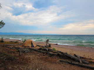 |
| Campsite on Agawa Bay, Lake Superior |
Stargazing: Excellent
Summary: A rugged, beautiful and accessible backcountry camping option
Thoughts: I've been wanting to visit Lake Superior Provincial Park for a long time. Many a traveler has recounted the awe that struck them upon setting sight on the north shore of Lake Superior, reputed to be one of the most beautiful places in Ontario (one person compared the quality of scenery to that of Killarney Provincial Park). Needless to say, expectations were high when I made the 10 hour drive to the park; I can report that the reputation is well deserved. The hilly terrain, with cliffs blanketed in mixed forest adjacent to Lake Superior's thunderous waterfront feels very unique in Ontario, leading you to realise that there are indeed "mountains" in the province. The landscape captured by the boundaries of Lake Superior Provincial Park provides an incredible representation of the beauty of this region. If you have not been to Lake Superior, you
need to go.
 |
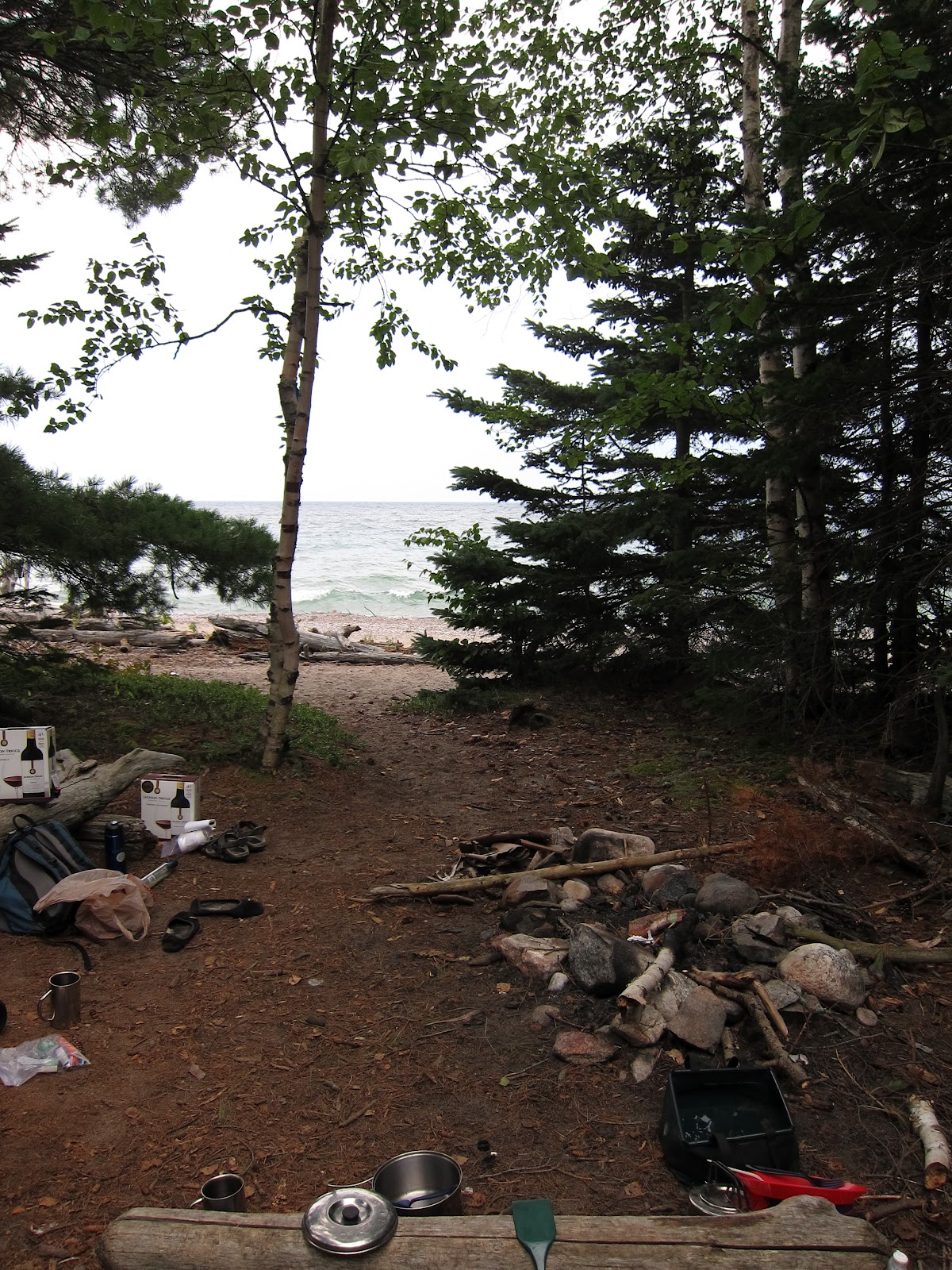
| Fire pit adjacent to Lake Superior |
The park is defined primarily by the Trans Canada highway (#17) that runs though it; looking at a map, the highway seems to snake through the centre of the park, with side roads feeding further into the park interior. There are plentiful opportunities to do quick day trips to inland lakes or overnight portaging/hiking trips. Fortunately, the highway doesn't hug the shoreline for the entire length of the park, providing a reprieve from the din of near constant truck traffic for those camping along the Coastal Trail. Unfortunately for us, we found ourselves at one of the portions where the highway meets the coastline, at Agawa Bay, just north of the Agawa River, primarily out of convenience - it's one of the few spots where you camp within reasonable proximity of a car so that you can make day trips to do some of the many hikes within the park. If you're parking at the trailhead immediately north of the bridge over the Agawa River (on the south side of the road), the hike into the first site is probably no more than 5 minutes from the access point. We hiked to what we could discern as the second site (it may have been the 3rd since there was a spot that seemed to be an overgrown site), about a 20 minute walk from the car. It was nice to find the site well-stocked with firewood and that had an amazing tent pad right on the sandy beach. Finding this site is probably more tricky than it needs to be, given that none of the sites are marked with signs (see below). However, relative to the other sites we'd passed, this one was the most obvious.
No reservations are necessary (or even possible) when staying at the interior campsites; when I first contacted the park, they said that even my late arrival (6pm) would not pose a problem if I wanted to grab a site that night. Upon arriving at the park, we found the park staff at the gatehouse somewhat ignorant of the backcountry (it seemed to be their first summer); when describing our planned hike, they just kind of nodded along without really adding any information. We had to figure out where the best place to park the car would be and the most direct route to the site on our own. In the end though, everything worked out very well once we got out of the car.
.jpg) |
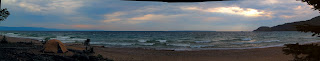
| Panorama of our Agawa Bay campsite |
The first day of our stay was probably an anomaly for Lake Superior weather; there was nearly no wind and sun was shining brightly. Given the shallow water of the bay and the considerable amount of warm weather that had been experienced up until this point in early August, the water was bearable for swimming (probably around 15 C). In fact, considering the clarity/cleanliness of the water, that we had the beach to ourselves (campers at the next closest campsites were tiny specks, a good 300-400 metres away) and that plant life cannot likely take root in the sandy, cold north shore, I would say it was one of the best swimming experiences I'd ever had. It was even more fun when the winds picked up a few days later, some of the biggest waves I've seen anywhere, lake or ocean (well, it's the largest freshwater lake in the world, by area, so it will get choppy). I thought to myself that Bill Mason must have been one heck of a strong paddler to canoe this shoreline solo.
If I were to have one complaint (other than the highway noise, which was really my own doing by choosing a site that was so close to the road), it is the poor markings of campsites; we didn't even realize that the first site we saw was indeed a campsite until we noticed people setting a campfire there after we'd already settled into our own site. As well, the park map states that all campsites are marked by a blue diamond with a white "tent" symbol. We did indeed see the blue diamond shape at our site, but not the site we had passed by, nor was there a white tent symbol on our site's marking - sure, this is a minor issue given how obvious it was that our own site was meant for camping (firepit and benches clearly visible from the trail). However, since the trail markers are also blue diamonds (with a little white "hiker" symbol), a less obvious site could easily be missed. Whether or not that is an issue along the trail, we couldn't say, but it is definitely something to be aware of.
We did make a quick trip to the car campground at Agawa Bay and would strongly recommend
against staying at any of the sites on the eastern sides of any of the loops as some of these have a clear view onto the Highway 17 (as mentioned earlier, the truck traffic will get irritating). Most of the electrical sites are wide open (zero privacy), but if you're spending your time in a trailer, then you probably don't mind all that much. The waterfront sites in the south campground (odd numbers from 227 - 255, even numbers from 322-344) all seemed quite nice, as long as the weather holds up.
All things considered, the scenic, rugged landscape of the north shore of Lake Superior provides excellent camping opportunities in a beautiful setting, with the potential for seclusion with not much work. The car camping at Agawa Bay should probably be avoided (though nearby Crescent Lake might be an inland alternative since the sites here are available on a first-come, first-served basis). As well, the hiking opportunities are some of the best and most accessible in the province. Well worth 10 hours in the car, if you can spend at least 2 full days in the park.
 |
| View from Awausee |
Hiking: The hiking at the
Awausee trail was spectacular; even scattered showers didn't diminish the scenery of the hike. In particular, the second lookout provides an incredible view of Agawa Bay and the Agawa Valley and is a nice spot to grab a bite and gaze blankly at the view below you. The guides to this trail all state that it is 4-6 hours, but we did it in 3 1/2 (excluding the stop for a lunch break, but including stops to catch our breath). The final 3rd of the hike follows a path within the Agawa Valley which is nice at first, but soon gets monotonous and seems to go on forever.
The Agawa Bay Pictographs trail is well worth the minimal effort that you need to expend. The pictograph area can get crowded (there's a narrow section of rock that you need to walk along, which can't really hold more than 2 abreast so it's a bit of a bottleneck), and you might have to wait your turn to have a look. You'll be filled with reverence when seeing these images, when considering the importance this area has to the native peoples of Lake Superior. I recommend that you go early in the day or later in the evening so you can take your time admiring these (though if the winds are really whipping up on Superior, you might want to keep away as it can be treacherous).
Note: I had originally posted photos of the pictographs, but realised much later that this is disrespectful to indigenous communities (in fact, I have read that taking photos of pictographs is strongly discouraged). In the end, I think photographs do not properly convey the beauty of these religious markings, so it is better that you see it for yourself (the pictographs alone are worth the trip to the park).


.jpg)
.jpg)


.jpg)
